• Flygkartor AA Route Maps       • Air_Maps

  American Airlines Inc. - Route Maps ~1945

These maps show American Airlines Inc. system of flight routes around 1945. The first version of these maps was published in 1938!
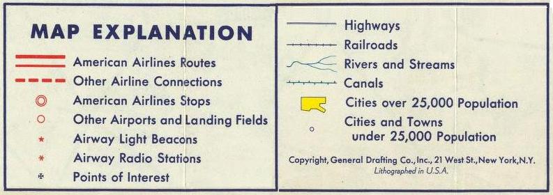
• AA System Overview Map with nice drawings.

Navigation was made with Radio beacons (6-stars in maps) and Light beacons (5-stars in maps).
- Radio beacons at airports, and at long legs also some inbetween. Light beacons much closer to each other.

Source: David Rumsey Historical Map Collection
Link to their excellent scanning: • AAR Map - zoom in!
  Click on maps and texts below for larger images!
1. Boston - New_York - Washington 2. Chicago - Buffalo 3. Buffalo & Toronto - New York 4. Chicago - St.Louis 5. St.Louis - Ft.Worth 6. Chicago - Washington 7. Boston - Cleveland 8. Cleveland - Nashville 9. Albany - New York 10. Chicago - New York 11. Los Angeles - Dallas 12. Dallas - Washington Cloud Atlas Cloud Atlas Radio Beam - Highway of the Air


  Last updated: 12 September, 2012, Bo Justussson, Stockholm
  Contact: justusXownit.nu - change X to @